Reimagine network expansion with inseyet

inseyet – The platform for complete transparency and the highest standards in infrastructure development

see more. build better.

Keep an eye on your entire network expansion project – live, digital, automated. inseyet offers you a powerful 360º monitoring system – digital 3D measurement via smartphone, recording of FTTH construction status & progress including documentation – all on one platform.
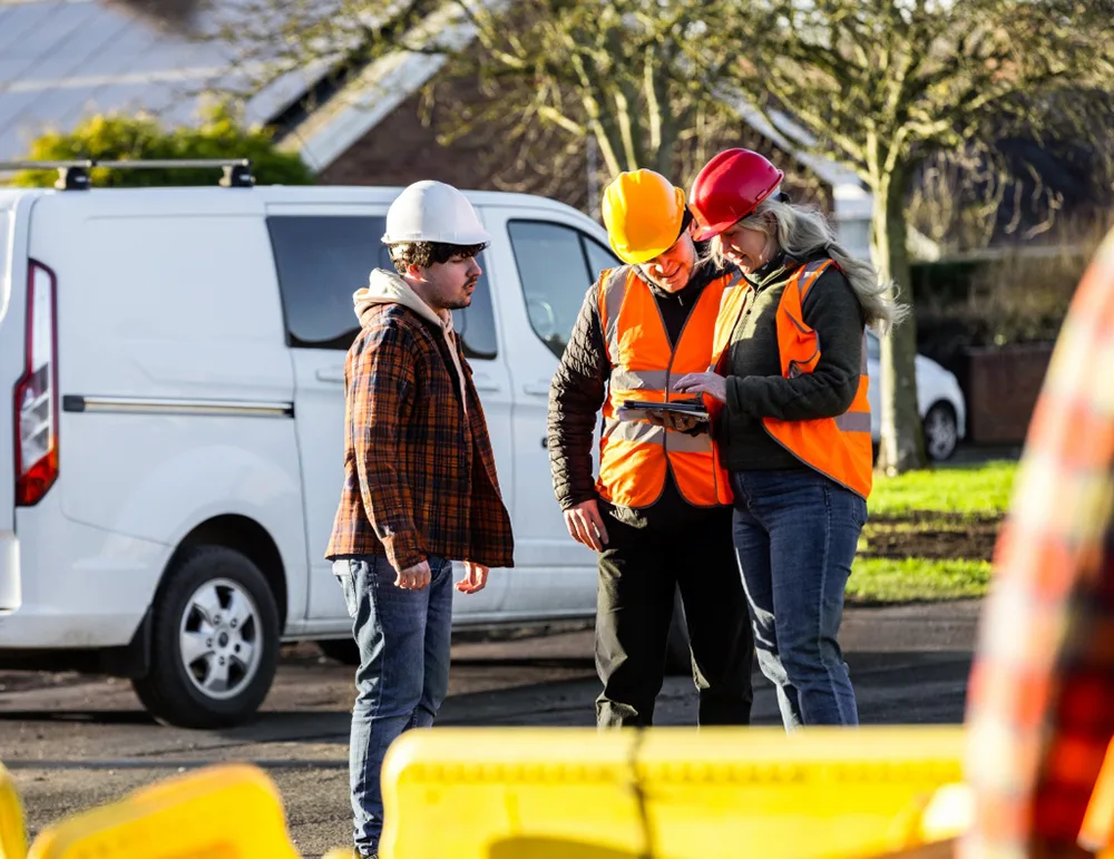
Efficient control

Efficient Control

Efficient control

Efficient Control

Surveying

3D Measurement

Surveying

3D Measurement

Digital network documentation

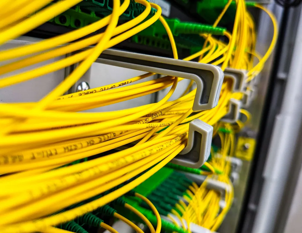
Digital Network Documentation

Digital network documentation

digital
network documentation

News

Ready for the future of infrastructure development?

say hello to inseyet

inseyet rover
inseyet rover

inseyet is a platform consisting of several combinable modules for the efficient control, digital measurement, and documentation of network infrastructure projects – whether fiber optic, electricity, or heating networks.

The platform bundles digital tools and services, allowing customers to select exactly the modules they need and, if required, connect them to their existing systems – from the construction phase to final documentation or billing.

What challenges does inseyet address?

inseyet rover
From the construction site to the office

What advantages does inseyet offer?

Our cooperation for inseyet:
developed from practical & process expertise

Our Partnership for inseyet

netzkontor nord and Fiber Experts combine their expertise to jointly rethink digital construction processes in fiber optic expansion: Operational experience meets IT expertise – with the goal of making infrastructure projects more efficient, transparent, and future-proof.

inseyet is the result of this partnership

A platform by experts for experts that prevents errors directly on the construction site – through digitalization where it counts and provides real insights.

netzkontor nord
fiber experts
Our shared vision: Error prevention – directly on the construction site.

FAQ

inseyet is a digital platform for the efficient planning, management and documentation of infrastructure projects – for example in FTTH expansion, electricity grid construction or similar expansion projects.

The platform comprises several central functions:

Digital 3D calibration

  • Precise recording of construction sites, routes and components
  • Visual representation of the expansion status in 3D
  • Support for various calibration systems – additional 3D calibration tools can be flexibly connected to the platform

Comprehensive technical documentation & project management

  • Task and process management for own teams and subcontractors
  • Illustration of the complete expansion status including route progress
  • Structured documentation of all construction and project activities in a central system

Data & integrations

  • Direct evaluations, analyses and reports in the platform
  • Data provision for BI tools
  • APIs for transmission to customers, external systems or other specialist software

Thanks to the use of an RTK rover in combination with an NTRIP service, measurement accuracies of less than 5 cm can be achieved in practice. However, this high precision is dependent on several factors:

  • RTK status: A stable, correctly set up RTK correction is crucial.
    Accuracies in the centimeter range can only be reliably achieved
    with a “fixed” solution.
  • Ambient conditions: High buildings, trees, terrain edges or other
    sources of interference can affect the GNSS signal and reduce the accuracy
    .
  • Satellite coverage: A sufficient number of well-positioned satellites
    improves the measurement quality.
  • Equipment & method of operation: The accuracy also depends on the quality of the
    GNSS receiver, the antenna positioning and the correct
    execution of the measurement.

In short: a 3D scan and the associated calibration can be very precise – < 5 cm
are realistic and common if RTK-Fix and good ambient conditions are available.

We use two central hardware components to create precise 3D models:

  1. iPhone Pro with LiDAR sensor
    Our 3D scanning function is based on the integrated LiDAR scanner of the iPhone Pro models. This sensor generates high-resolution depth data and enables the fast and reliable recording of rooms, construction progress and surfaces. All iPhone Pro and Pro Max models from iPhone 14 Pro are supported.
  2. viDoc Light as RTK rover
    We use the viDoc Light for exact positioning data. The RTK rover provides centimeter-accurate georeferencing so that the generated 3D models can be precisely located in the terrain or construction project.

The combination of LiDAR scanning and RTK surveying gives you particularly accurate, stable and fully georeferenced 3D models – ideal for construction, infrastructure and documentation projects.

Classic measurement
In classic measurement, individual points of an object or terrain are recorded using surveying equipment (e.g. total station, GPS rover). The result is a list of points or 2D/3D coordinates of individual measuring points.

  • Only defined measuring points (e.g. edges, corners, axes) are recorded.
  • The accuracy is high, but the level of detail depends on the number of points measured.
  • The result often has to be transferred manually to plans or CAD models.

3D measurement (e.g. LiDAR-based scan)
In 3D measurement, not just individual points but entire surfaces and environments are recorded over their entire surface. A LiDAR scanner generates a dense point cloud from millions of measuring points.

  • The entire room or building is automatically and seamlessly digitized.
  • Changes, damage or deviations are directly visible.
  • The result is a precise 3D model that can be used immediately for planning, documentation or
    BIM.

In short:

  • Classic calibration: selective, manual, very precise, but less detailed.
  • 3D measurement: full-surface, automatic, extremely detailed and ideal for digital
    models

For more information about the inseyet platform, simply use our contact form or say hello and email us directly at hello@inseyet.de. We will be happy to take your requirements and expectations on board and give you an initial insight into the possibilities of inseyet – including the individual modules such as:

  • Status and factual documentation
  • Extensive evaluation and analysis functions
  • Digital calibration via the inseyet app, including 3D scan and georeferencing

Our team will then contact you directly to discuss your individual use cases and questions

The data generated by the 3D scan provides a complete and highly accurate representation of the real condition of a construction project or object. This opens up numerous application possibilities:

  • Detailed construction progress documentation
    Thanks to the full-surface recording, changes, progress and deviations can be precisely tracked throughout the entire construction process. Each scan depicts a transparent, verifiable status at a specific point in time.
  • Creation of complete as-built documentation
    The point clouds and 3D models enable the reliable creation of as-built documentation. These serve as a digital basis for planning, invoicing, handovers or subsequent conversions.
  • Mandatory documentation according to the specifications of major clients
    Many infrastructure operators – including Deutsche Telekom – require precise, georeferenced documentation of the actual condition for certain projects. Our 3D scans meet these requirements and can be used directly for the prescribed documentation processes.

The data is also suitable for quality assurance, collision checks, quantity takeoff, as-built surveys and further processing in CAD or BIM systems.